简介
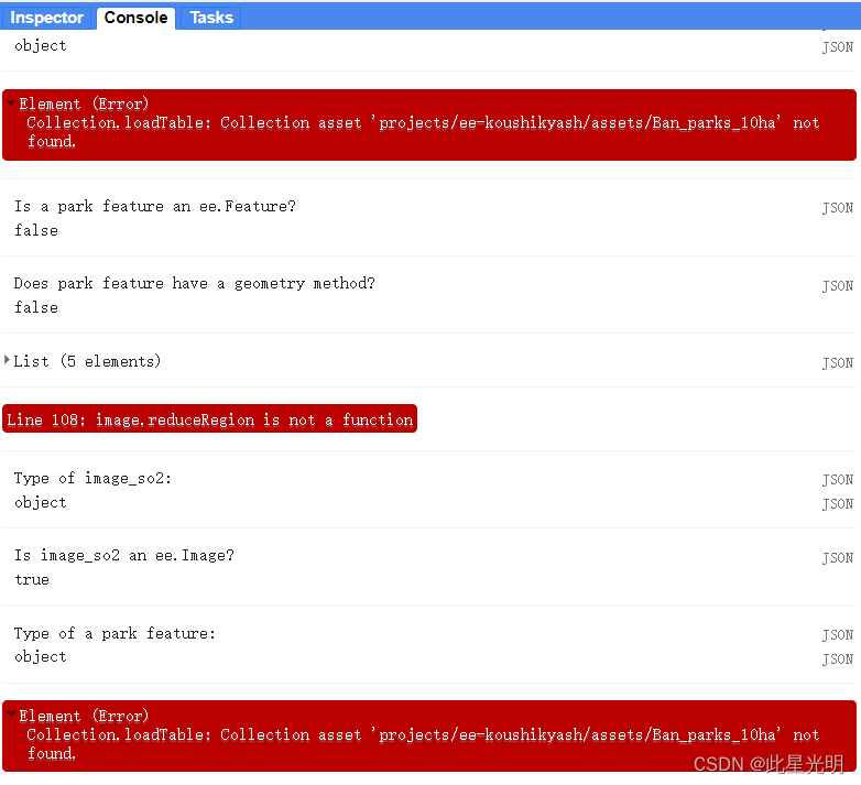
image.reduceRegion is not a function
这里的主要问题是我们进行地统计分析的时候,我们的作用对象必须是单景影像,而不是影像集合
错误"image.reduceRegion is not a function" 表示你正在尝试使用reduceRegion()函数来处理图像数据,但是该函数在所使用的图像对象上并不存在。这通常发生在以下几种情况下:
-
你使用的图像对象并不是由Earth Engine提供的图像数据类型。只有Earth Engine提供的图像数据类型,如Image、ImageCollection等,才包含reduceRegion()函数。确保你使用的图像对象是Earth Engine提供的类型。
-
你使用的图像对象是一个空对象或没有加载任何数据。如果图像对象为空,那么该对象上是没有reduceRegion()函数的。请确保你加载了正确的图像数据,或者使用其他方法创建图像对象。
请根据具体情况查看你的代码,并根据上述解释进行适当的修改。
代码
var landsat = ee.ImageCollection("LANDSAT/LC08/C02/T1_L2"),imageVisParam = {"opacity":1,"bands":["B7","B6","B4"],"min":11451.624047549685,"max":13348.162011801593,"gamma":1},blore = /* color: #0b4a8b *//* shown: false *//* displayProperties: [{"type": "rectangle"}] */ee.Geometry.Polygon([[[77.1829215561055, 13.595511689413932],[77.1829215561055, 12.530677550689433],[78.1167594467305, 12.530677550689433],[78.1167594467305, 13.595511689413932]]], null, false),pol_CO = ee.ImageCollection("COPERNICUS/S5P/OFFL/L3_CO"),pol_NO2 = ee.ImageCollection("COPERNICUS/S5P/OFFL/L3_NO2"),pol_CH4 = ee.ImageCollection("COPERNICUS/S5P/OFFL/L3_CH4"),pol_SO2 = ee.ImageCollection("COPERNICUS/S5P/OFFL/L3_SO2"),pol_O3 = ee.ImageCollection("COPERNICUS/S5P/OFFL/L3_O3");
var parks = ee.FeatureCollection('projects/ee-koushikyash/assets/Ban_parks_10ha');var i = 1;
var bufferDis = 50// create new buffer
var newBuffer = function(feature) {var geometry = feature.geometry();var buffer = geometry.buffer(bufferDis * i);// print(i)buffer = buffer.difference(geometry)var newFeature = ee.Feature(buffer, feature.toDictionary());return newFeature;
};// subtract geometry
var subtractGeometries = function(feature1, feature2) {var geometry1 = feature1.geometry();var geometry2 = feature2.geometry();return geometry1.difference(geometry2);
};var allBuffers = ee.List([])var parks_0 = parks;
Map.addLayer(parks_0, {}, 'Buffer around Bangalore Parks ' + (0));
allBuffers = allBuffers.add(parks_0)
var prev = parks_0
var colors = ["Red", "Green", "Orange", "Yellow", "Pink"]var total = 5;
for(var j = 0; j < total; j++){var parks_1 = parks.map(newBuffer)var temp = parks_1parks_1 = parks_1.map(function(f1) {var index = parks_1.toList(parks_1.size()).indexOf(f1)var f2 = ee.Feature(prev.toList(prev.size()).get(index))return ee.Feature(subtractGeometries(f1, f2), f1.toDictionary())});// changing stateprev = tempi += 1allBuffers = allBuffers.add(parks_1)Map.addLayer(parks_1,  {color: colors[j]}, 'Buffer around Bangalore Parks ' + (i));
}//Add pollutant images
var image_so2 = pol_SO2.filterBounds(parks).filterDate('2024-01-01', '2024-01-31').select('SO2_column_number_density').mean().clip(parks)var image_no2 = pol_NO2.filterBounds(parks).filterDate('2024-01-01', '2024-01-31').select('NO2_column_number_density').mean().clip(parks)var image_ch4 = pol_CH4.filterBounds(parks).filterDate('2024-01-01', '2024-01-31').select('CH4_column_volume_mixing_ratio_dry_air').mean().clip(parks)var image_o3 = pol_O3.filterBounds(parks).filterDate('2024-01-01', '2024-01-31').select('O3_column_number_density').mean().clip(parks)var image_co = pol_CO.filterBounds(parks).filterDate('2024-01-01', '2024-01-31').select('CO_column_number_density').mean().clip(parks) // Check the type of image
print("Type of image_so2:", typeof image_so2);// Check if image_so2 is an ee.Image object
print("Is image_so2 an ee.Image?", image_so2 instanceof ee.Image);// Check the type of park
print("Type of a park feature:", typeof parks.get(0));
print(parks.first());
// Check if a park feature is an ee.Feature object
print("Is a park feature an ee.Feature?", parks.first() instanceof ee.Feature);// Check if the geometry method is available on a park feature
print("Does park feature have a geometry method?", parks.get(0).geometry !== undefined);// var sampleFeature = parks.first();
// var geometry = sampleFeature.geometry();
// print("Geometry of sample feature:", geometry);// var featureCount = parks.size();
// print("Number of features in parks:", featureCount);// Function to calculate pollutant statistics for each park
var calculateStatistics = function(image, park) {var stats = image.reduceRegion({reducer: ee.Reducer.mean().combine({reducer2: ee.Reducer.minMax(),sharedInputs: true}),geometry: park.geometry(),scale: 30,maxPixels: 1e9});// Map over the stats to format them as featuresvar features = ee.Feature(null, stats).set('date', image.date().format('YYYY-MM-dd')).set('park_name', park.get('name')); // Assuming 'name' is the property containing park namesreturn features;
};// Function to get statistics for all pollutants and parks
var getResults = function(parks, images) {var results = ee.List(images).map(function(image) {var stats = parks.map(function(park) {return calculateStatistics(image, ee.Feature(park));});return stats;}).flatten();return results;
};// Function to format the results
var format = function(table) {var rows = table.distinct('date');var columns = parks.aggregate_array('name'); var formattedResults = rows.map(function(row) {var date = row.get('date');var parkStats = table.filter(ee.Filter.eq('date', date));var values = parkStats.aggregate_array('pollutant_min', 'pollutant_max', 'pollutant_mean');return ee.Feature(null, values).set('date', date);});return formattedResults;
};// Export to CSV function
var exportToCsv = function(table, desc, name) {Export.table.toDrive({collection: table,description: desc,fileNamePrefix: name,fileFormat: "CSV"});
};// Assuming you have defined the pollutant images (image_so2, image_no2, etc.) and parks beforehand// Get data for all pollutants and parksvar image_so2 = pol_SO2.filterBounds(parks).filterDate('2024-01-01', '2024-01-31').select('SO2_column_number_density').mean().clip(parks)var image_no2 = pol_NO2.filterBounds(parks).filterDate('2024-01-01', '2024-01-31').select('NO2_column_number_density').mean().clip(parks)var image_ch4 = pol_CH4.filterBounds(parks).filterDate('2024-01-01', '2024-01-31').select('CH4_column_volume_mixing_ratio_dry_air').mean().clip(parks)var image_o3 = pol_O3.filterBounds(parks).filterDate('2024-01-01', '2024-01-31').select('O3_column_number_density').mean().clip(parks)var image_co = pol_CO.filterBounds(parks).filterDate('2024-01-01', '2024-01-31').select('CO_column_number_density').mean().clip(parks) var images = [image_so2, image_no2, image_ch4, image_o3, image_co]; //checking the type of iamges array
print(images);var results = getResults(parks, images);// Format the results
var formattedResults = format(results);// Export the formatted results to CSV
exportToCsv(formattedResults, "PollutantStatistics", "pollutant_stats");
正确解析
这里的正确思路是我们需要进行分析,也就是说我们的作用对象是影像,而非影像集合,所以这里我们不能混淆这里两个概念,首先看一下两个函数的差异:
ee.Image(args)
An object to represent an Earth Engine image. This constructor accepts a variety of arguments:
-
A string: an EarthEngine asset id,
-
A string and a number: an EarthEngine asset id and version,
-
A number or ee.Array: creates a constant image,
-
A list: creates an image out of each list element and combines them into a single image,
-
An ee.Image: returns the argument,
-
Nothing: results in an empty transparent image.
Arguments:
args (Image|List<Object>|Number|Object|String, optional):
Constructor argument.
Returns: Image
ee.ImageCollection(args)
ImageCollections can be constructed from the following arguments:
-
A string: assumed to be the name of a collection,
-
A list of images, or anything that can be used to construct an image.
-
A single image.
-
A computed object - reinterpreted as a collection.
Arguments:
args (ComputedObject|Image|List<Object>|String):
The constructor arguments.
Returns: ImageCollection
这是两个之间的差异,然后再看reduce region的函数
reduceRegion(reducer, geometry, scale, crs, crsTransform, bestEffort, maxPixels, tileScale)
Apply a reducer to all the pixels in a specific region.
Either the reducer must have the same number of inputs as the input image has bands, or it must have a single input and will be repeated for each band.
Returns a dictionary of the reducer's outputs.
Arguments:
this:image (Image):
The image to reduce.
reducer (Reducer):
The reducer to apply.
geometry (Geometry, default: null):
The region over which to reduce data. Defaults to the footprint of the image's first band.
scale (Float, default: null):
A nominal scale in meters of the projection to work in.
crs (Projection, default: null):
The projection to work in. If unspecified, the projection of the image's first band is used. If specified in addition to scale, rescaled to the specified scale.
crsTransform (List, default: null):
The list of CRS transform values. This is a row-major ordering of the 3x2 transform matrix. This option is mutually exclusive with 'scale', and replaces any transform already set on the projection.
bestEffort (Boolean, default: false):
If the polygon would contain too many pixels at the given scale, compute and use a larger scale which would allow the operation to succeed.
maxPixels (Long, default: 10000000):
The maximum number of pixels to reduce.
tileScale (Float, default: 1):
A scaling factor between 0.1 and 16 used to adjust aggregation tile size; setting a larger tileScale (e.g. 2 or 4) uses smaller tiles and may enable computations that run out of memory with the default.
Returns: Dictionary
具体分析
这里其实最主要的问题是我们作用的对象是image,但是这里我们要写入function的时候,我们写入的方式不对,所以这里出现了错误,这里的问题就在于我们需要重新解析我们的函数,函数需要重新分开来操作,整体的思路是我们要map,也就是对每一个操作的影像进行分析,然后添加属性什么的问题就可以进行了。